Table of Contents >> Show >> Hide
- What a Fall Foliage “Peak” Map Actually Shows
- How Leaves Turn Color (And Why Some Years Are Better Than Others)
- How to Use a Fall Foliage Map Like a Pro
- Typical Peak Windows by U.S. Region (A Helpful Cheat Sheet)
- Planning Tips for Peak Color Without Peak Stress
- What to Watch in the 7 Days Before You Go
- Where a “Peak Map” Helps the Most: Realistic Scenarios
- Extra: of Fall Foliage Experiences to Get You in the Mood
- Conclusion
If you’ve ever planned a “quick little leaf-peeping weekend” that turned into a
“why are all the trees still green?” road trip (or worse: “why are all the leaves on the ground?”),
welcome to the club. Fall color is magical, but it’s also a moving targetmore like a traveling concert tour
than a single date on the calendar. The good news: today’s fall foliage maps and trackers make it way easier
to time your trip, your hike, or even your “I swear I’m just stepping outside for five minutes” photo walk.
In this guide, we’ll break down how fall foliage prediction maps work, what “peak” really means,
how weather can speed things up or dull the show, and how to use a map to find the most vibrant colors near you.
We’ll also share practical planning tips (including a few “don’t learn this the hard way” lessons) and end with a
longer, story-like experience section to get you fully in the autumn mood.
What a Fall Foliage “Peak” Map Actually Shows
Most popular fall foliage maps and trackers use a combination of seasonal climate patterns, recent weather,
and regional vegetation timing to estimate where leaves are changing and when they’re likely to be at their best.
Many maps categorize areas with labels like minimal change, partial, near peak, peak, and past peak.
Think of these as a “progress bar” for the landscape, not a promise written in permanent marker.
Even the best tools emphasize they’re forecastshelpful for planning, not a guarantee.
Peak doesn’t last longso timing matters
“Peak” is usually a short window. In many locations, the most vivid color can last roughly a week or so,
depending on wind, rain, and temperature swings. That’s why maps are so useful: you’re not just guessing a month
you’re narrowing down a specific week (and sometimes a specific long weekend).
Local variation is real (and kind of the whole game)
Two towns 30 miles apart can look totally different. Elevation, tree species, local moisture, and urban heat
can shift timing. Even within one park, a valley might still be green while a nearby ridge is already glowing.
That’s why the best strategy is using maps as your baseline, then fine-tuning with elevation and microclimate logic.
How Leaves Turn Color (And Why Some Years Are Better Than Others)
Here’s the science-y part, explained in human terms: trees aren’t being dramatic; they’re being efficient.
As daylight shrinks in fall, trees wind down photosynthesis. Chlorophyll (the green pigment) breaks down,
and other pigments become visibleyellows and oranges were often there all along, while reds and purples
can develop based on conditions like sunny days and cool nights.
The “perfect” recipe for vivid color
- Warm, sunny days to keep energy production going.
- Cool nights to help boost red pigment development in some species.
- Good soil moisture through late summer/early fallstressed trees often drop leaves early.
- Not too windy (wind can “end the show” overnight).
Many forestry and science sources point to this general pattern: cool nights, sunny days, and adequate moisture
often produce brighter, longer-lasting color, while drought, heat, and storms can shorten or dull the season.
What can throw the timing off
Weather can nudge fall color earlier, later, or flatter (yes, foliage can be “meh,” and it’s rude).
Warmer falls can delay the cues trees use to shift into dormancy and sometimes shorten the most brilliant phase.
Drought stress can cause early leaf drop or browning before colors fully develop. Early frosts can damage leaves,
reducing the reds in particular.
How to Use a Fall Foliage Map Like a Pro
The fastest way to get value from a foliage map is to treat it like a planning dashboard:
use it to choose when to go, then use geography to decide where to go.
Many widely used maps update with seasonal progression and provide a visual timeline of color moving south
and downslope over the weeks of fall.
Step 1: Identify your “target week,” not a single day
Aim for a 7–10 day window. If your map says “near peak” this week, that’s often your cue to start watching
daily updates (and quietly cancel your other plans, obviously).
Step 2: Use elevation to your advantage
Higher elevations usually change first. If your region is “early,” head to mountains and high ridges.
If your region is “past peak” up high, drop into lower valleys, lakeside routes, and sheltered forests.
This one trick can rescue a trip when timing isn’t perfect.
Step 3: Look for mixed forests for a longer show
Areas with diverse native tree species often have a more layered, longer-lasting display because different species
change at different times. That’s why some landscapes seem to “hold color” for weeks while others flash bright
and then move on.
Step 4: Sanity-check with local sources
Maps are the big picture. For the final call, check park updates, local travel advisories, or foliage reports.
Regional trackers from major weather outlets often include current-condition notes that explain whether the season
is running early/late and why.
Typical Peak Windows by U.S. Region (A Helpful Cheat Sheet)
Exact timing changes year to year, but foliage generally “travels” from north to south and from high elevation to
low elevation as fall progresses. Forecasting outlets and seasonal guides frequently describe a pattern where
northern tier states and higher elevations peak earlier, followed by the mid-latitudes, and then the deep South later.
Northeast & New England
Often the headline act of fall color. Many years see earlier color in northern areas and higher elevations, with peak
conditions commonly arriving from late September into October depending on location and elevation.
Upper Midwest & Great Lakes
Expect strong color progression across forests and lake country, often tracking similar timing to the northern tier,
then drifting later as you move south.
Rockies & Mountain West
Elevation rules everything here. Aspen groves can light up early at higher elevations, while foothills and lower valleys
can peak later. If you’re flexible, you can “chase peak” by driving up or down in elevation.
Pacific Northwest
Timing varies with elevation and local conditions. Some forecasts note that certain years can be more muted in parts of the
Northwest depending on heat and moisture patterns.
Appalachians & Southeast
Higher elevations in the Appalachians can change earlier than surrounding lowlands, while the broader Southeast often peaks later
into the season, with some areas holding color well into late fall.
Planning Tips for Peak Color Without Peak Stress
Build a “two-option” itinerary
The smartest leaf-peeping plans have an A plan and a B plan. If wind strips the ridge overnight, your backup is the river drive.
If a warm stretch delays color, your backup is a higher elevation trail. Forecasting can be excellent, but weather still has opinions.
Pick your “color personality”
- Big, bold reds: Look for regions known for maples and conditions with cool nights and sunny days.
- Golden yellows: Aspens and birches can deliver a bright, glowing look, especially in mountain regions.
- Rusty oranges and bronzes: Oaks can lean warm and rich, often later in the season.
Go early or go weird (in the best way)
If you can’t travel, you can still catch great color locally by choosing the right moment:
early morning light, a waterfront path, a botanical garden, or an older neighborhood with mature trees.
Urban heat can delay color slightly compared to surrounding rural areas, so city parks can be a sneaky “late-season” option.
Respect the place (so it stays beautiful)
Stay on trails, avoid trampling fragile areas for the “perfect angle,” and be mindful of private land.
Popular leaf spots get crowded fastarrive early, park legally, and pack out what you pack in.
What to Watch in the 7 Days Before You Go
A foliage map gives you the “where.” The week-of details come down to weather:
- Wind and heavy rain: can drop leaves quickly and shorten peak.
- Warm nights: can reduce red pigment development in some cases.
- Prolonged drought: can dull color and trigger early drop.
- Early frost: can damage leaves and mute the display.
If the map says “near peak,” and you see a calm forecast with cool nights and bright days, that’s your green light
(ironically, for not-green leaves).
Where a “Peak Map” Helps the Most: Realistic Scenarios
Scenario 1: You want the best color within a 2-hour drive
Use the map to find the nearest “near peak” zone, then choose a route with elevation changes (even modest hills).
Add a park, a lake loop, and one scenic overlook. If you hit peak early, great. If not, you still get a solid fall day.
Scenario 2: You’re planning flights and need a smarter bet
Choose a region with diverse forests and multiple elevations so you have options if timing shifts.
That might mean basing yourself near a mountain corridor or a national forest area with lots of drives and trailheads.
The more “layers” your destination has, the more resilient your trip is to a surprise heat wave or a windy front.
Scenario 3: You want family photos that look like a fall movie poster
Choose “near peak” rather than “past peak,” and prioritize places with mixed species (for more color variety).
Shoot during golden hour, and bring a backup outfit because someone will spill cider. Not “might.” Will.
Extra: of Fall Foliage Experiences to Get You in the Mood
Imagine you’re holding a warm coffee that’s doing its best to keep your fingers functional while your breath makes tiny clouds
in the air. The foliage map said your area was “near peak,” which is the leaf-peeping equivalent of “your food is on the way.”
You don’t fully trust itbut you’re excited enough to put on a sweater that’s 60% cozy and 40% static electricity.
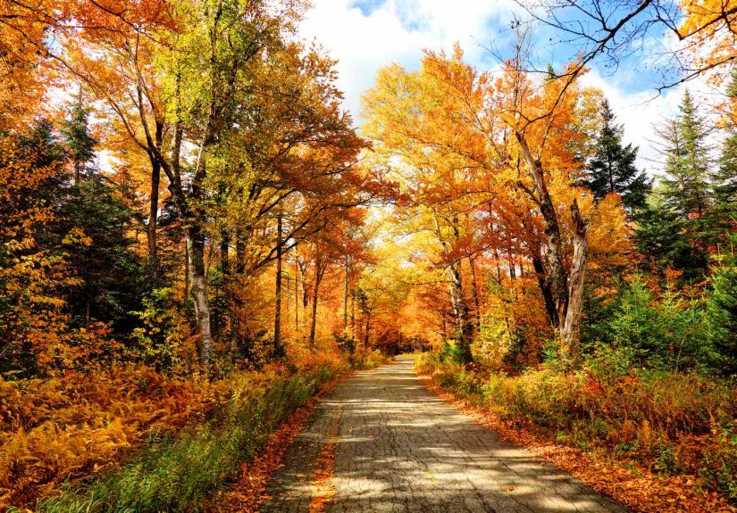
The first stop is a quiet back road you’ve driven a hundred times, except today it looks brand-new.
A line of trees has turned into a gradientlime green at one end, then lemon yellow, then orange, then a shocking red that looks
like it was added with a paintbrush. You realize fall color isn’t just “pretty”; it’s dynamic. It feels like the landscape
is mid-transformation, and you accidentally arrived during the best scene.
You pull into a small park and hear the crunch. Not the “oops, that’s my phone screen” crunchgood crunch.
The kind that makes you slow down on purpose because it sounds like autumn itself is applauding your choices.
A couple walks by holding hands, and you wonder if leaf-peeping is secretly a national love language.
Nearby, a kid kicks a pile of leaves and immediately disappears into the chaos they created.
It’s a reminder that peak season doesn’t have to be a serious, tripod-only event. It can be messy, loud, and perfect.
Later, you take the map’s advice and head uphill. Suddenly, the colors intensify like someone turned up the saturation.
The air gets cooler, the light changes, and you see why elevation matters: one ridge can be “peak,” while the valley below is still
warming up. You start to understand the foliage map as a conversation starter, not a final verdict.
It points you in the right direction, and then you use your eyesand a little curiosityto finish the job.
Then comes the classic fall moment: the lookout. Everyone gets quiet in that shared, unplanned way.
The view isn’t just trees; it’s texture and depthevergreens anchoring the scene while deciduous trees glow around them.
You take photos, but you also pause because photos never fully capture what it feels like to stand there,
watching sunlight move across a hillside like a spotlight. You don’t need to “do” anything. You just get to be there.
On the drive home, you notice the small details you normally miss: a single branch turning scarlet above a sidewalk,
a patch of golden leaves reflected in a pond, the way the sky looks sharper when the air is cool and dry.
You’re tired, a little hungry, and probably carrying a donut (or three) you swear are “for later.”
And you realize the best fall foliage experiences aren’t only about chasing the perfect peak.
They’re about letting the season slow you down long enough to actually see where you are.
Conclusion
Fall foliage doesn’t have to be a guessing game. With a reliable peak map, a basic understanding of how weather influences color,
and a flexible plan that uses elevation and local variation, you can dramatically increase your odds of catching those vibrant reds,
oranges, and golds right when they’re at their best. Use the map to choose your window, build a backup option, and let the season
surprise youin the good way.